Village history
Please let us know if you have any old photographs or books relating to the village history
Old Photographs of Main Street
The following two photographs have been reproduced courtesy of the Fife Arms. They feature the pub when it was a single story building. Do you know when these photographs were taken or do you who is in them?

The Fife Arms, Milton of Balgonie

Fife Arms and Main Street
Fife Policing History Volume 1The following extract comes from the Fife Policing History volume 1. It paints the villagers of Milton as real reprobates....do you have any photographs of 27 Main Street as the Police station? If so please get in touch. |
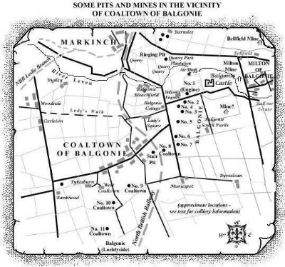
Pits and mines around Milton The Milton mine by Balgonie link below has an interesting article from "The Scotsman" 20 April, 1921 about the trial of seven miners from Coaltown of Balgonie for contraventions of the Emergency Powers Act, 1921. The accompanying map is also from the same website and shows the local pits. The Happy Lands, a Fife made featue film featuring two Milton youngsters is currently being toured in the UK and features the 1926 General Strike and miners lock out. The film reflects the realities of life in the Fife mining communities at that time and draws on local stories very much like those featured in this news article. |
- A vision of Britain through time between 1801 and 2001 - 1882-4, Frances Groome's Ordnance Gazetteer of Scotland described Milton of Balgonie like this: Balgonie, two villages and an estate in Markinch parish, Fife. Balgonie proper or Milton of Balgonie stands on the left bank of the river Leven, 1mile ESE of Markinch station; and has a post office under Markinch, and a former chapel of ease, with 650 sittings, erected in 1875 into a quoad sacra church. Flax-mills are adjacent, and form three sides of a rectangle, 160 by 140 feet.,,,,,
- EXCERPTS FROM THE 1861 PAROCHIAL DIRECTORY FOR FIFE AND KINROSS - MARKINCH, which is in the Kirkcaldy district of the County, is bounded by the parish of Kennoway on the east, by Wemyss on the south, by Dysart, Kinglassie, and Leslie, on the west, and by Falkland and Kettle on the north. A small section, containing the village of Innerleven, or Dubbieside, at the mouth of the Leven, is cut off from the rest of the Parish by that of Wemyss. This portion is about one and a quarter mile distant from the nearest point of the main body of the Parish. Its length from north to south is about six miles, and its greatest breadth four miles. It contains the villages of Markinch, Milton, Coaltown, Balcurvie, Windy-gates, Thornton, Woodside, Balbirnie Bridge, and Kirkforthar Feus........
- Milton Mine, by Balgonie - The Milton Mine was located less than a mile east of Balgonie Castle but little detailed information has been uncovered about the nature of the mine or minerals worked. It would appear that there was an electric plant associated with the colliery in this locality which was responsible for supplying power for ventilation and pumping purposes in the Balgonie pits.......
")